The Libyan Desert is part of our country, and it is incumbent upon us to ascertain our borders there, so that we may better know our country. By traversing the desert I will have established some of the rights of our nation.
Ahmed Hassanein, The Lost Oases (1925)
Historians of the modern Middle East have typically treated Egypt as a special case. Unlike the other Arabic-speaking nation-states to emerge from the ashes of the Ottoman Empire after World War I, Egypt, so the story goes, has maintained a continuous and stable territorial identity over its long and dynamic history. But this narrative is belied by the curious story of the “first modern political map” of Egypt (see Map 1).1
This map was a key part of the settlement that Mehmed ‘Ali reached with the Ottoman government in 1840,2 concluding a decade-long power struggle between the rogue Egyptian governor and his imperial suzerain.3 On February 13, 1841, Sultan Abdülmecid I issued a firman (decree) that outlined the basic terms of the agreement: in exchange for withdrawing Egyptian forces from Syria and Palestine and reducing the size of his standing army, Mehmed ‘Ali would receive the right to hereditary rule over Egypt. Often overlooked in accounts of this historic firman of investiture, however, is the map that came with it. This is a curious oversight, considering that the text of the decree explicitly defined the scope of Mehmed ‘Ali’s rule as the territory “contained within the ancient limits depicted on the map” sent by the Grand Vezir.4 Although the 1841 firman was an unprecedented concession by Istanbul, the map still served the important function of circumscribing Mehmed ‘Ali’s ruling authority, by clarifying Egypt’s position within the broader domain of Ottoman imperial sovereignty.
The image of Egypt inscribed in the 1841 map—which the Ottomans understood to represent the province’s “ancient” and “known” territorial limits—differs significantly from that of the present-day nation-state. This is most apparent when we examine the map’s depiction of Egypt’s borders, all of which fall well short of their current location. In the south, the map’s borderline intersects the Nile at around Aswan, approximately 155 miles north of the present border (which cuts across instead at Wadi Halfa). In the east, the map leaves a large portion of the Sinai Peninsula outside Egypt, marking the territory instead as part of the Hijaz (the western coastal region of present-day Saudi Arabia). Finally, in the west, the border commences from a point along the Mediterranean coastline corresponding roughly to present-day Marsa Matruh (more than 125 miles east of the current border, which lies just west of the port of Sollum).5
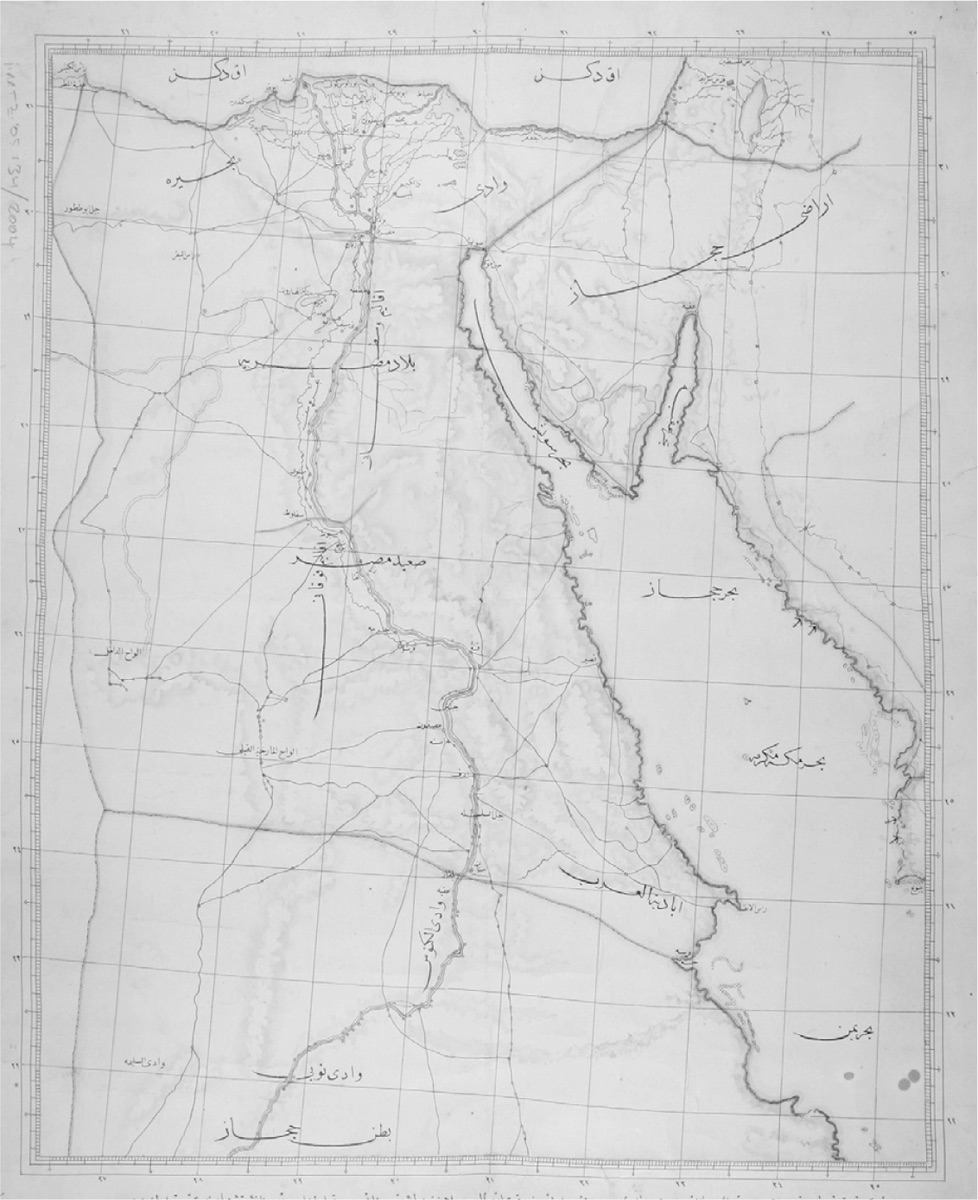
The extent to which the Ottomans’ mid-nineteenth-century conception of Egypt’s territorial shape diverges from the present-day Egyptian “geo-body”6—the standardized, infinitely reproducible mapped image of the country—is only the first of the 1841 map’s surprises. Despite the Ottoman government’s best intentions, the map’s inclusion with the firman actually settled very little. For over three-quarters of a century, in fact, this first map of modern Egypt went missing. It was not published along with the firman,7 and—although both the Ottoman and Egyptian governments were aware of its special significance for establishing the terms of Egypt’s legal-political relationship with the Ottoman state—no one seems to have been able to locate it in Egypt prior to World War I.8
This was not for lack of trying. In 1892, during the initial phase of a persistent conflict between the Ottomans and the British over control of the Sinai, the Ottoman Grand Vezir lamented that the map could not be found in Cairo, since it alone could “establish the legal bounds of the [Ottoman] state.”9 A decade and a half later, during the height of the Sinai border crisis (also referred to as the Taba or Aqaba incident), the Ottomans again searched in vain for this “map showing Egypt’s borders.”10 The British also called attention to the mysterious absence of this telltale map. In 1907, Lord Cromer, the consul-general of Egypt, observed that “this map is supposed to have been lost in a fire which destroyed a great part of the Egyptian Archives. The Turkish copy is occasionally alluded to by the Porte, no one has ever seen it, and its existence appears doubtful.”11
The elusive map surfaced only in 1925, on the eve of a diplomatic settlement between Egypt and Italy, which led subsequently to the delimitation of Egypt’s western border. In the course of their negotiations with the Italian government, the Egyptian authorities searched anew for the map but, once again, could not find it anywhere in Cairo. In May, the Egyptian Ministry of Foreign Affairs appealed to its ambassador in Turkey to look for the map in Istanbul’s archives; several months later he finally located a copy and sent it to Egypt. This copy was then published along with the official western border treaty, signed on December 6, 1925.12
The inclusion of the 1841 Ottoman map with the Egyptian-Libyan border settlement of 1925 was an ironic choice, given how little the map seems to have mattered for over half a century. Ever since the emergence of the new “critical cartography” in the mid-1980s,13 historians of nationalism have viewed maps as powerful tools, or “weapons,”14 of nation-state formation.15 Thongchai Winichakul—the author of a pathbreaking study of mapping’s role in the making of modern Thai nationalism—has suggested that it is the presumed authenticity of cartographic knowledge that makes the inscription of mapped images of the nation so profoundly influential.16 National maps derive much of their power from rendering invisible the messy configurations of social relations that actually exist on the ground at the time the maps are made.17 Maps thus never merely reflect some objective spatial reality of the national community; rather, they create a new reality by forging a legible, panoptic image of bounded national territory. This is what made them such indispensable tools in the hands of modernizing and centralizing states throughout the nineteenth century.18
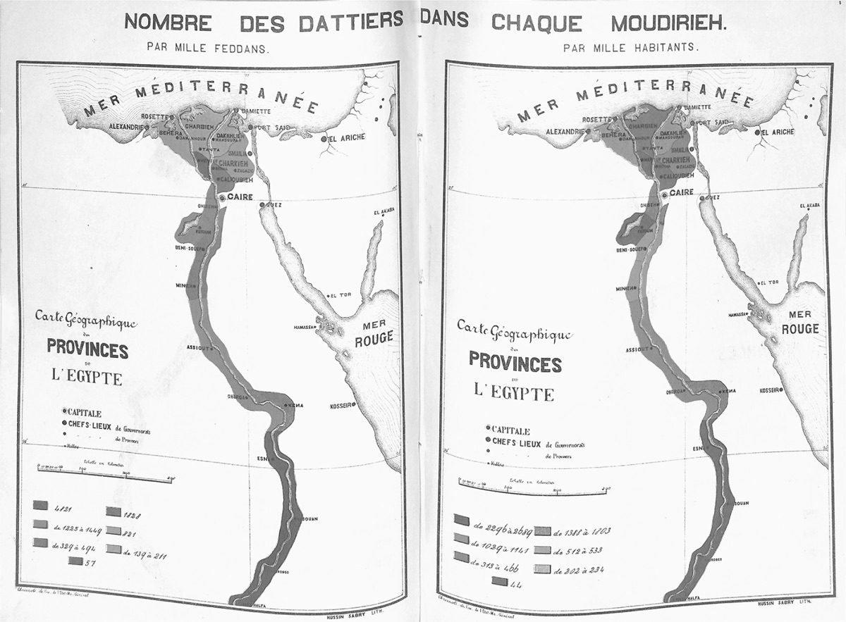
Egypt was different, however. Over the second half of the nineteenth century, the production of a definitive, clear-cut border map outlining the territorial shape of the nation was not a primary objective of the state. Instead, government officials were preoccupied with a very different sort of mapping. In the 1870s, the Egyptian Interior Ministry produced a series of maps to showcase various statistical data they had collected on the geographical distribution of different resources (see Map 2); the representation of all the land beyond the Nile Valley and Delta as so much white space suggests just how inconsequential the state deemed Egypt’s borderlands at this time. The state’s particular cartographic fixations were no different under British occupation. From 1898 to 1907, the Egyptian Survey Department worked to produce a “great land map of Egypt,” intended, in the words of Timothy Mitchell, to “determine, for every square meter of the country’s agricultural land the owner, the cultivator, the quality of the soil, and the proper rate of tax.”19 The sort of cartography that mattered to the colonial state, then, was specifically tailored to the twinned goals of promoting administrative efficiency and collecting revenue. The only Egyptian domains worth representing were those that were productive; the country’s desert borderlands, which had little perceived value, had no place on the great land map.20
The lack of a precise conception of “cartographic Egypt”21 before World War I was paralleled by the limited consideration of Egypt’s territorial expanse by geographers and nationalist intellectuals. Insofar as these groups did concern themselves with the territorial contours of Egyptian identity, it was to assert an ambiguous discourse predicated on the “Unity of the Nile Valley.”22 The emergence of the “Unity of the Nile Valley” trope in the 1890s was part of a larger wave of interest in geography that burgeoned in Egyptian elite and intellectual circles over the last quarter of the nineteenth century. In 1875, as part of his initiative to widen the scope of Cairo’s literary and cultural institutions and promote Egypt as a place of serious scientific learning, the Egyptian Khedive Isma‘il (r. 1863–79) established the Société Khédiviale de Géographie d’Égypte—an intellectual salon for an array of explorers and amateur scholars, European and Egyptian alike.
From the outset, however, the Society’s major thrust was not to research the geography of Egypt, which it seems to have taken largely for granted, but rather to provide a scientific foundation for Egypt’s own colonial projects in Central Africa and the Sudan—most typically by sponsoring survey expeditions and ethnographic studies. In this way, the geographical knowledge produced under the Society’s auspices served its members’ underlying ideological aim of asserting Egypt’s modernity by setting the country apart from the rest of the African continent in civilizational terms.23 As the Society’s first president, German geographer George Schweinfurth, explained, “The Geographical Society of Cairo has all the advantages offered by a country which on the one hand is in intimate contact with European civilization, and on the other touches the most mysterious lands of central Africa. We are here at the gateway of the unknown.”24
If the vanguard of Egyptian geographical knowledge production at the time remained so narrowly focused on the African interior, the few Egyptian scholarly works from the period that did specifically address Egypt’s territorial scope were strikingly vague in their conceptions of the land to the east and west of the Nile. Muhammad Amin Fikri’s pioneering 1879 treatise Jughrafiyat Misr (The Geography of Egypt) is an important example of this tendency. As Yoav Di-Capua has suggested, Fikri’s volume was likely the first Egyptian work of “national geography” to embrace the “European territorial concept” of nationhood.25 Accordingly, the first line of the book presents the so-called “natural” boundaries of Egypt, “a great state in the northeast of Africa.” Despite this promise of more precise territorial definition, however, Fikri’s descriptions are actually quite vague. Egypt’s western border is identified simply as “the Libyan Desert.”26 Similarly, a geographical dictionary of Egypt published two decades later fell back on the amorphous formulation that, “properly speaking . . . Egypt is bordered on the West by the Libyan Desert”; this led the author to conclude that “the Western frontier does not have precise limits.”27
Egypt’s path towards modern nation-statehood in the nineteenth century thus unfolded without a precise definition of a national “geo-body,” circumscribed within clearly demarcated borders. Despite the absence of authoritative representational practices to forge the nation, however, Egypt began to emerge steadily as a modern territorial nation-state over the half-century before World War I. This book seeks to explain how this came to pass, by documenting the territorialization of the vast region I call the “Egyptian West”—one of the desert borderlands that had been left clear off the 1841 map.
Territoriality is a fundamental characteristic of modern nation-state formation, and yet it is often overlooked by historians, who tend to treat it as a static background rather than a contingent historical artifact that has had specific variations across space and time.28 Historian Charles Maier, whose oeuvre constitutes a noteworthy exception to this rule,29 has defined territoriality as “the properties, including power, provided by the control of bordered political space, which until recently at least created the framework for national and ethnic identity.”30 According to Maier, modern territoriality “developed alongside, indeed as a component of, the ideas of modern sovereignty” that coalesced in Europe in the seventeenth century and were rendered more concrete with the Treaties of Westphalia. In this formative stage of modern territoriality, the onus for statesmen was on delimiting the contours of their sovereign control by drawing borders and, whenever possible, fortifying them. Over the next century, territoriality evolved so that the notion of “organizing space within borders”—squeezing as much revenue and resources as possible out of the lands under state control—became every bit as fundamental to prevailing conceptions of state sovereignty as boundary making had been in the earlier period.31
The technological advances of the industrial age ushered in a new era of what Maier calls “intensified territoriality.”32 Compelled by the period’s rapid innovations in transportation, communications, and infrastructure, modernizing states around the globe embraced an ideal of territorial mastery that would have been unthinkable in an earlier age. To be a modern power in the nineteenth century meant that states needed to harness these technologies to achieve more coherent and uniform centralized control over the entirety of their domains. As Maier explains, state territoriality was now conceived as a totalizing energy field: “The center would radiate its energy outward along lines of communication (telegraphs and railroad) and implant local sources of national energy, whether schools or prefectures, throughout the territory. Every point on the map should contribute to the vitality and efficiency of the whole.”33
This, at least, was the nineteenth-century territorial ideal. In practice, however, the territorialization projects that many states undertook in this period looked rather different. Although Maier concedes that “there are alternative concepts for claiming shares of global space and seeking territorial stability without fixed frontiers,”34 his historical framework loses specificity when he writes about the ascendancy of bordered territoriality by 1890, after which “there was really no territory ‘beyond the line’ outside Antarctica” (only some “ambiguous and contested areas”).35 This formulation overlooks the range of alternate mechanisms for forging conceptions of bounded political space in the nineteenth century beyond the drawing of borderlines. Territoriality as practiced in the nineteenth century might have been modular, but it was not universal; as Will Hanley has recently argued for the related term nationality, territoriality had (and has) local particularities, which are themselves historical products that require careful contextualization and sifting.36 If it is true that territoriality was a fundamental feature of nineteenth-century nation formation, it does not follow that modernizing states around the globe pursued only one avenue toward achieving it.
Egypt is an apt case for exploring alternate dynamics of nineteenth-century nation-state territorialization, especially considering how little Egypt’s border regions seemed to matter at the time the country was first given modern political definition in 1841. In this book, I seek to explain the emergence of modern Egyptian territoriality by adopting the view from the margins—illuminating the little-known history of the Egyptian-Libyan borderland, where a range of state- and nation-making projects unfolded over the half-century before World War I. Throughout this period, a sharper sense of bounded political space—a heightened awareness of the existence of distinctive Egyptian and (Ottoman) Libyan territorial spheres—began to develop in this desert borderland despite the absence of any clear-cut boundary markers or cartographic evidence. National territoriality was not simply imposed on Egypt’s western (or Ottoman Libya’s eastern) domains by centralizing state power, however. Rather, it emerged only through a complex and multilayered process of negotiation with the region’s predominantly bedouin and oasis-dwelling inhabitants, who were animated by their own local conceptions of space, sovereignty, and political belonging.
To advance this argument, Desert Borderland, drawing on some recent anthropological literature,37 explores what I call the lived experience of territoriality as the conceptual lens that best enables scholars to capture the dynamic interaction between state and local actors in the forging of modern bordered political identities. Viewed this way, territoriality as it was practiced in the nineteenth century was not the sole province of state power—something that the center simply injected into the peripheries using the various administrative technologies at its disposal—but rather more of a feedback loop. Just as centralizing states were forced to adapt their territorial imperatives in light of the diversity of local spatial practices they encountered across their sovereign domains, so, too, were these various local spatial practices transformed by their encounter with modern nation-state building. The ways in which various local actors related to and inhabited space changed along with state territorialization projects; their spatial practices indeed became more self-consciously territorial.38
The borderland that Egypt shared with Ottoman Libya presents a particularly illuminating case study for exploring territoriality in this manner. Though sparsely populated, this vast swath of the Eastern Sahara was home to a rich tapestry of local denizens, ranging from numerous pasto-ralist bedouin tribes, to itinerant merchants operating along the Mediterranean coast, to sedentary agricultural communities settled for centuries in the various oases dotting the desert interior. For these populations, the desert borderland was not “marginal,” as it would have been seen from the seats of state authority in Cairo or Istanbul, but rather the very locus of their spatial identity. Moreover, beginning in the mid-nineteenth century, the borderland also became the home base for the Sanusiyya—a mystical Islamic brotherhood that grew rapidly in the ensuing decades, galvanizing a striking proportion of the region’s population. Through its encounter with the centripetal pull of both the Egyptian and Ottoman states, the Sanusiyya behaved increasingly like an embryonic territorial state in its own right, with its headquarters in the oasis of Jaghbub emerging by the late nineteenth century as an alternate sovereign center.
By adopting the view from the borderland, this book recasts the history of Egyptian nation-state formation as well as Ottoman re-centralization after the Tanzimat.39 Territoriality as lived by the local population in the Eastern Sahara clashed repeatedly with the various centralizing projects introduced by both states during this period, but it also shaped these projects in fundamental ways. The chapters that follow document several crucial instances of this dynamic: the key role that the Sanusiyya and other local elites played in accommodating Egyptian state sovereignty in the borderland; the ways that bedouin mobility across the invisible “border” prompted both governments to reexamine the scope of their territorial definition in the region; and the competition between the Ottomans, Egyptians, and Italians to curry favor with local populations in their bid for territorial mastery in the Eastern Sahara in the decade before World War I.
Egypt’s borderlands have been completely overlooked in the historiography of Egyptian nation-state formation. Particularly in light of much recent scholarship that has amply traced the discursive contours of national subjectivity in colonial Egypt,40 the degree to which the territorial dimension of Egyptian nation-statehood has been taken for granted is rather startling.41 This tendency has manifested in different ways. On one hand, much scholarship produced in Egypt, operating within a firmly nationalist paradigm, treats the country’s territoriality as sacrosanct—a timeless essence of Egyptian identity that it is pointless, even dangerous, to question. In geographer Gamal Hamdan’s multivolume study Shakhsiyat Misr (The Personality of Egypt), for example, Egypt’s unique natural landscape—anchored by the fertile Nile Valley and Delta—molded a distinctive Egyptian national character that has endured ever since the time of the Pharaohs.42
On the other hand, the question of territoriality has fallen by the wayside even in much western historical scholarship on modern Egypt. It is understandable that the field’s long-standing emphasis on documenting Egypt’s encounter with European empire has naturally led many scholars to fix their gaze upon Cairo—the center of the colonial state, where British power was at its height, as well as the primary stage for the evolution of anti-colonial nationalism in the decades prior to World War I. This focus has had the unintended effect of obscuring much Egyptian history beyond the capital. Only in recent years have scholars begun to challenge Cairo-centric histories of modern Egypt by exploring alternate geographies within the emergent nation-state.43 But even as Egypt’s secondary cities, as well as its agricultural interior, have garnered increasing scholarly attention, the country’s expansive desert borderlands are still neglected.44
This study’s close attention to territorial dynamics in the borderland does more than merely fill a geographical lacuna, however; it also offers a unique lens through which to view Egypt’s complex, multi-layered political history after 1841. Despite its concession of hereditary rule to Mehmed ‘Ali at this time, the Ottoman government remained deeply invested in exercising nominal sovereignty over Egypt—now classified as a special “autonomous province” (eyalet-i mümtaze) within the imperial domains—even as the Egyptian state under the Khedives continued to expand and operate independently of Istanbul. The British military occupation of Egypt in 1882, which morphed seamlessly into the open-ended “Veiled Protectorate,” added another layer to the composite structure of the Egyptian state. This rendered Egypt’s sovereign status even more opaque:45 henceforth, until World War I, Egypt would now have three sovereign masters—the Ottoman sultan; the Egyptian khedive (a member of the Mehmed ‘Ali dynasty);46 and the British consul-general (Lord Cromer, from 1882–1906).
Sovereignty is a fundamental premise of modern territoriality, but it would be a mistake to assume that it necessarily implies a unitary source of authority across a given state’s domains.47 James Sheehan has suggested that sovereignty “is best understood as a set of claims made by those seeking or wielding power, claims about the superiority and autonomy of their authority.” Yet this sovereign claim-making never occurs in a vacuum. Rather, it is always the case that “claims imply counterclaims and contestation,” so that “sovereignty involves not only asserting power but also constantly testing, extending, and sometimes accepting power’s limitation.”48 Viewed in this way, sovereignty in practice has never worked according to the Westphalian ideal—the exercise of uniform centralized control over bounded state space—but rather has always been a matter of relative capability and reach, as state actors vie for ruling legitimacy in a competitive field.49
Adopting the view from the western borderland allows us to see the inner workings of Egypt’s contested state sovereignty along these lines. Throughout the late nineteenth century, the region was transformed into a dynamic space for the articulation of overlapping sovereign claims and counterclaims by various agents of centralizing authority—the Ottoman, British-Egyptian, and (later) Italian states, but also the Khedive ‘Abbas Hilmi II (r. 1892–1914), who pursued his own territorial projects across the Egyptian West in hopes of bolstering his status as the true, independent sovereign of Egypt.
Such an oblique view of the political machinations at the center of state power offers several advantages. First, it suggests a slightly alternate periodization for modern Egyptian history. From the vantage point of the borderland, Egypt’s enduring Ottoman connection remains central to understanding the unfolding of events50—even after 1882—while the period of British colonial rule in Egypt appears more as one additional layer in a larger story of political and territorial transformation. Second, this approach recasts our understanding of colonial governance in late-nineteenth-century Egypt, by enabling us to see the delicate negotiations of power on a local level that British rule necessarily entailed. At the same time, the British appear more marginal in Desert Borderland than they do in most studies of late-nineteenth-century Egypt. In the story of borderland territorialization that unfolds in these pages, a multiplicity of state and non-state actors propelled events forward; accordingly, the edifice of British colonial power recedes somewhat into the background.
To reconstruct the multiple layers and meanings of territoriality in the Egyptian-Libyan borderland, this book draws from an expansive range of primary sources from the Ottoman, Egyptian, Italian, and British state archives; the personal papers of the Khedive ‘Abbas Hilmi II; and a number of published memoirs, historical periodicals, and legal manuals. The objective throughout has been to read many of these disparate sources in tandem, and also against the grain, in order to hear not just from politicians and statesmen in Cairo, Istanbul, or Rome, but also from minor bureaucrats, local governors, judges, scribes, Sanusi brethren, bedouin tribesmen, and local shaykhs in the remote western oases. As the pioneering borderland historian Peter Sahlins has written in another context, “if there is a single history to the boundary and the borderland, it must take into account this multitude of voices, many of which can barely be heard.”51
1. Geographer Gideon Biger coined this term for the 1841 map. See Biger, “The First Map of Modern Egypt”; Biger, “The First Political Map of Egypt.”
2. Enclosed with Başbakanlık Osmanlı Arşivi (BOA): İ.MTZ(05) 34/2004 (Jan. 6, 1906 / 30 Zilkade 1323). The text at the bottom reads as follows: “This is a copy of the sealed map, drawn up in the office of the Imperial School of Military Engineers, that was graciously sent when the Province of Egypt was granted to the late Mehmed ‘Ali Pasha with the privilege of inheritance in 1256 [A.H.; 1841 A.D.].” The map appears to be a modification of the well-regarded Jacotin map, drawn by surveyors during the French occupation of Egypt from 1798–1801 and published in 1816. Biger, “First Political Map,” 88.
3. The standoff began when the Egyptian army occupied Ottoman Syria and Palestine in 1831. At one point, Mehmed ‘Ali’s forces advanced within approximately sixty miles of Istanbul. It was only British military intervention that thwarted the Pasha’s designs and compelled him to reach a compromise with the Ottoman government. See Fahmy, Mehmed Ali.
4. Hatt-ı Şerif of Feb. 13, 1841 (21 Zilhicce 1256). A second firman, issued that same day, addressed Egypt’s possessions in the Sudan by offering a slightly different formulation: Mehmed ‘Ali would now control Nubia, Darfur, Kordofan, and Sennar, in addition to “the Governorship of Egypt, comprised within its known limits.” See Association Égyptienne de Paris, Documents diplomatiques concernant l’Égypte.
5. The map indicates Ras al-Kana’is as the precise point along the coastline where the borderline begins (Marsa Matruh, which only grew to become a town of any consequence in the mid-twentieth century, was not labeled).
6. Winichakul, Siam Mapped, 16–18; 129–40.
7. Brownlie, “Arab Republic of Egypt-Libya,” 103–4.
8. According to Egyptian historian Fatima ‘Alam al-Din ‘Abd al-Wahid, the map was lost or concealed deliberately. ‘Abd al-Wahid, Ḥudūd Misr al-gharbiyya, 11–12. See, also, Biger, “First Political Map,” 83–84.
9. BOA: Y.A.HUS 256/51.
10. BOA: İ.MTZ(05) 34/2004 (Jan. 6, 1906 / 30 Zilkade 1323).
11. Archivio Storico Diplomatico del Ministero degli Affari Esteri (MAE): Ambasciata d’Italia in Egitto (AIE) 117 (Cromer memo, June 14, 1907).
12. Royal Geographic Society, Foyle Reading Room (RGS): La Frontière Occidentale de l’Égypte, doc. 1.
13. For two influential examples of the new critical cartography, see Harley, New Nature of Maps; Wood, Power of Maps.
14. Wood, “How Maps Work,” 66.
15. Winichakul argues that “mapping created a new Siam—a new entity whose geo-body had never existed before.” Benjamin Fortna has shown how modern classroom maps that collated the totality of the Ottoman Empire’s domains within one image were vital instruments for producing a new generation of loyal Ottoman subjects. Firoozeh Kashani-Sabet, in her seminal study of territoriality in modern Iranian national discourse, shrewdly argues that “the mapping of ‘Iran’ reinforced the sense that something concrete sustained the idea”—in short, that the emergence of modern nationalism was contingent upon the ability of Iranians to see the nation. Winichakul, Siam Mapped, 130; Fortna, Imperial Classroom, ch. 5; Kashani-Sabet, Frontier Fictions, 17.
16. As Winichakul puts it, for the case of Thailand: “The geo-body of a nation is merely an effect of modern geographical discourse whose prime technology is a map. To a considerable extent, the knowledge about the Siamese nationhood has been created by our conception of Siam-on-the-map, emerging from maps and existing nowhere apart from the map.” Winichakul, Siam Mapped, 17.
17. As Timothy Mitchell has suggested, political life in modern territorial nation-states requires that people “reduce the significance of those interconnections, exchanges, genealogies, hegemonies, moral systems, and migrations that defined a social landscape whose horizons reached beyond what became the boundaries of the nation.” Mitchell, Rule of Experts, 180. At the same time, however, national maps always fall short of their ultimate objective: they never completely circumscribe the contours of the imagined nation. As Peter Perdue has pointed out in his study of Qing China’s westward expansion, an “ironic gap between the surveyors’ claims to universal, standardized abstract space and the local particularities of place” inevitably threatened to unsettle the territorial imperatives of modernizing states. Perdue, China Marches West, 460.
18. Winichakul, Siam Mapped; Edney, Mapping a Nation; Kashani-Sabet, Frontier Fictions; Craib, Cartographic Mexico; Burnett, Masters of All They Surveyed; Carter, Road to Botany Bay. Benedict Anderson also addressed the importance of national maps as discursive tools in the second edition of Imagined Communities.
19. This was a significant improvement on the state’s past attempts at cadastral mapping, particularly given that trigonometrical survey methods were being used for the first time. Mitchell, Rule of Experts, 9; 85–94. As Aaron Jakes has recently pointed out, another striking feature of Egypt’s trigonometrical survey project—even more historically consequential than the creation of a panoptic “great land map”—was the production of tens of thousands of smaller cadastral maps that circulated widely. See Jakes, “State of the Field,” introduction.
20. British colonial officer Claude Jarvis would later claim that the cadastral map of 1907 remained “surrounded by a huge white space of untouched paper” until well after World War I; before then, “everything outside the cultivation of the Nile was an unknown quantity as far as real survey work was concerned.” Jarvis, Three Deserts, 105–6 (quoted in Fletcher, British Imperialism and the “Tribal Question,” 85).
21. This language is a deliberate nod to Raymond Craib’s Cartographic Mexico. For Craib, in contrast to the Egyptian case, national mapping was one of the main “spatial fixations,” or top-down territorial imperatives, of the nineteenth-century Mexican state. Craib goes on to suggest that these state fixations were constantly thwarted by “fugitive landscapes—“intensely local settings” that were “created and recreated through the prisms of memory, practical wisdom, use, and collective decision making.” Craib, Cartographic Mexico, 8–12.
22. This was an interesting paradox: leaving aside the seemingly more obvious question of how to conceive the territorial bounds of Egypt proper, these intellectuals posited instead a complex definition of territorial Egyptianness that hinged on their country’s putative inseparability from the Sudan. This dynamic is treated in depth in Eve Troutt Powell’s pathbreaking Different Shade of Colonialism. Omnia El Shakry has called this discursive move an “ideological bid for territorial integrity based on ethnographic and geographic claims.” El Shakry notes that this discourse gained currency in the 1890s, against the backdrop of Great Britain’s reassertion of military control in the Sudan, which culminated in the signing of the Condominium agreement in 1899. El Shakry, Great Social Laboratory, 74–83.
23. This idea that Egypt consistently sought to distinguish itself from the rest of Africa through its own colonial projects in the Sudan and further south is another salient theme of Troutt Powell’s work.
24. Quoted in Donald Reid, “The Egyptian Geographical Society,” 541. The quote is taken from one of Schweinfurth’s texts published in the Bulletin de la Société Khédiviale de Géographie de l’Égypte, series 1 (1875–76).
25. Di-Capua, Gatekeepers of the Arab Past, 48–49. Di-Capua argues that Fikri’s work broke from the time-honored Ottoman-Egyptian khitat tradition, which approached geography through the lens of city-hinterland relationships, and is exemplified most famously by ‘Ali Mubarak’s al-Khiṭaṭ al-Tawfiqiyya al-jadīda li-Misr al-Qahira wa-muduniha wa-bilādiha al-qadīma wa-l-shahīra.
26. The full first line of the text is as follows: “Egypt is a great state in the Northeast of Africa. Its natural boundary to the north is the Mediterranean Sea; to the east it is the Gulf of Suez and the Red Sea; to the west it is the Libyan Desert; and to the south it is the lands of Nubia.” Fikri, Jughrāfiyat Misr, 1.
27. Boinet, ed., Dictionnaire géographique de l’Égypte.
28. By contrast, territoriality has been richly theorized in the social sciences—particularly by geographers. Robert Sack, Human Territoriality, remains a key touchstone for this literature.
29. See also Goswami, “From Swadeshi to Swaraj”; Osterhammel, Transformation of the World, 107–13.
30. Maier, “Consigning the Twentieth Century to History,” 808.
31. Maier, Once Within Borders, 9–12; emphasis in original. See also Maier, “Transformations in Territoriality.”
32. Maier, Once Within Borders, 194.
33. Ibid., 231. This analysis of the mechanisms of nineteenth-century state centralization (particularly railroads and schools) is reminiscent of Eugen Weber’s classic work on French state-building under the Third Republic, Peasants into Frenchmen.
34. Maier, Once Within Borders, 5.
35. Ibid., 228.
36. Hanley, Identifying with Nationality, 8–9. See also Goswami, “Rethinking the Modular Nation Form.”
37. Ismael Vaccaro, Allan Charles Dawson, and Laura Zanotti suggest that territoriality connotes multiple “processes involved in the social translation of space as an abstract category into territory as a socially meaningful quotidian reality.” It entails ongoing negotiation, as “physical differences in space are made social through the communication of boundaries, markers, borders, patterns of usage, and histories of settlement.” What is particularly appealing about this framework is the scope it opens up for exploring the intersection between multiple layers and meanings of territoriality, and the “social processes triggered when different forms of territoriality are pushed by history to share the same space.” At the same time, however, this framework—by presenting territoriality as a universal feature of how humans interact as they move through space—loses sight of territoriality as a historical product, taking shape through the confluence of particular conditions at different key moments. Vaccaro, Dawson, and Zanotti, “Negotiating Territoriality,” 1–2.
38. Again, this conception of territoriality parallels Hanley’s analysis of how prevailing understandings of “nationality” evolved and spread in the same period. As Hanley puts it: “It is clear that top-down reform projects suggested communitarian frames for populations, and individuals and groups responded in the same idiom by adopting those frames. By the late nineteenth century, communitarian frames were an accepted rubric for political organization and social identification.” Hanley, Identifying with Nationality, 3.
39. In this vein, I am following in the footsteps of pathbreaking borderland historians such as Peter Sahlins, Michiel Baud, Willem van Schendel, Samuel Truett, and Elliott Young. The body of work these scholars have produced exemplifies how borderland histories allow us to glimpse broader aspects of state formation that are otherwise distorted or obscured by the center’s own perspective. As Baud and van Schendel have suggested, borderland historians “should ask which social and political impulses originated in borderlands and what effect they had . . . particularly in relation to state building on both sides of the border. The crucial question is what borderlands can teach us about ways of conceptualizing social space and local identity, and the roles these have played in promoting or thwarting the development of modern states.” Similarly, Truett and Young have argued that “struggles to delimit and define national and ethnic identities in the borderlands exposed the incoherency of the imagined bounded space of the nation.” Baud and van Schendel, “Toward a Comparative History of Borderlands,” 241; Truett and Young, “Making Transnational History,” 2.
40. As numerous scholars have shown, the major ideological thrust of Egyptian national discourse formation in this period was not the defense of the nation’s territorial integrity, strictly speaking, but rather the assertion of a robust anti-colonial identity, articulated most typically through the language of modernity. See: Gershoni and Jankowski, Egypt, Islam, and the Arabs; Lockman, “Imagining the Working Class”; Russell, Creating the New Egyptian Woman; Pollard, Nurturing the Nation; Baron, Egypt as a Woman; El Shakry, Great Social Laboratory; Gasper, Power of Representation; Jacob, Working Out Egypt; Gitre, “Performing Modernity”; Fahmy, Ordinary Egyptians; Ryzova, Age of the Efendiyya.
41. It is as though a generation of scholarship on Egyptian nation-statehood has simply taken the 1841 firman—with its vague gesture towards the “ancient” and “known” territorial bounds of Egypt—at its word. Examples abound, but we see this tendency in scholarship both old and new. Charles Wendell argued decades ago that the “geographical or territorial factor”—that “Egypt is determinable with unusual ease and little or no dispute”—greatly facilitated the rise of Egyptian national consciousness. Similarly, Ziad Fahmy has suggested that “the topography of Egypt . . . with most of its inhabitants living in an easily accessible thin strip of land stretching from Aswan to the Mediterranean, has historically facilitated centralization efforts.” Wendell, Evolution of the Egyptian National Image, 123–24; Fahmy, Ordinary Egyptians, 21.
42. See also: Hamdan, Ṣafaḥāt min awrāqihi al-khāṣṣa; ‘Abd al-Wahid, Ḥudūd Misr al-gharbiyya; Fawda, Ḥudūd Misr al-dawliyya; Khashshab, Tārīkh taṭawwur ḥudūd Misr; Muhammad Safi al-Din et al., Dirāsāt fī jughrāfiyat Misr; Quhayba, Dirāsāt fī jughrāfiyat Misr al-tārīkhiyya.
43. For Alexandria: Reimer, Colonial Bridgehead; Hanley, Identifying with Nationality; Hanley, “Papers for Going, Papers for Staying”; Minkin, “In Life as in Death”; Minkin, “Documenting Death.” For Upper Egypt: Abul-Magd, Imagined Empires; Reynolds, “Building the Past”; Rieker, “The Sa‘id and the City”; Derr, “Cultivating the State.” For the Delta: Jakes, “State of the Field”; Jakes, “The Scales of Public Utility”; Boyle, “Sickness, Scoundrels, and Saints.” For the Suez Canal and Red Sea region: Wick, Red Sea; Belli, Incurable Past.
44. The recent work of the “Dakhleh Oasis Project” is one laudable exception. See Peters, Wathā’iq madīnat al-Qasr bi-l-wāḥāt al-Dakhla. Additionally, Alan Mikhail’s Nature and Empire in Ottoman Egypt includes historical analysis of the oasis of Fayyum (sixty-two miles southwest of Cairo), though for the early modern period.
45. Not least in international law. See Genell, “Empire by Law,” for an extended analysis of the status of Ottoman Egypt within international law, as well as Istanbul’s ongoing diplomatic struggles with the British to retain a modicum of sovereignty over Egypt.
46. Although Mehmed ‘Ali and his descendants adopted the title of “khedive” (instead of wali) early on, it was not officially recognized by Istanbul until 1867, when Sultan Abdülaziz issued a firman that sanctioned its use by Isma‘il and his successors.
47. While I agree with Maier’s formulation of sovereignty and territoriality as “twinned concepts,” my analysis here diverges from his framework, which stipulates that sovereignty within a territorial state is indivisible. Maier, Once Within Borders, 9, 72–81.
48. Sheehan, “The Problem of Sovereignty,” 3.
49. This framework is reminiscent of early modern legal theorist Jean Bodin’s analysis of sovereignty. For Bodin, different political actors achieve ascendancy in a given domain by extending what he referred to as sovereign “marks” across space. See Benton, Search for Sovereignty, 131–37, 288–90. For a provocative analysis of sovereign capabilities through the lens of Bodin’s “marks of sovereignty,” see Lombard, “Raiding Sovereignty in Central African Borderlands,” introduction.
50. In emphasizing the continued salience of the Ottoman imperial context for modern state-building in Egypt, I am influenced by Khaled Fahmy’s historiographical intervention in All the Pasha’s Men.
51. Sahlins, Boundaries, 23.